The flood maps are all wrong.
The old water marks on grain elevators are meaningless.
This was the message Washington University geology professor presented to a small room of environmentalists, water experts and river rats at Union Station just a few months before the December floodwater came to St. Louis. We were both there to speak of an ongoing problem in our region: the failure to learn lessons from past floods.
Criss gave a preview of his paper, published later in the , arguing that the statistical methods used by the U.S. Army Corps of Engineers and the Federal Emergency Management Agency to define flood risk are outdated. Talk of 100-year or 500-year floods is meaningless, as are some of the flood plain maps, Criss said. The frequency of major flooding events, in part due to climate change but greatly due to bad river management, are increasing. The old math, he argued, needs some new equations.
People are also reading…
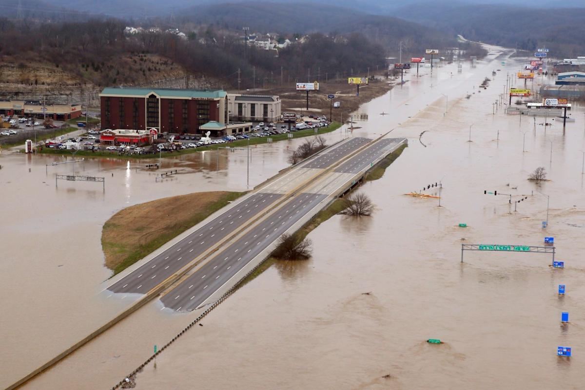
Months later, as rising water tops interstates, threatens levees and swallows towns such as Pacific and Union and West Alton, Criss has another message that many won’t want to hear:
This is our fault.
“The Mississippi River should not be going crazy after three days of rain,” Criss told me Wednesday morning.
Here, the Great Flood of 1993 is a good comparison, not because the high-water records are about to be broken, but because that flood was so different.
“1993 was a slow-moving monster,” Criss said. Water levels built upstream in the Missouri and Mississippi for days and weeks and months, moving slowly to each new city in its path. They behaved, mostly, as big rivers are supposed to, slowly building, taking in massive amounts of water, and searching for flood plain to relieve its swollen banks.
Eventually, relief came, from the river’s perspective at least, when it broke through the Monarch Levee and flooded the Gumbo Bottoms in what is now known as the Chesterfield Valley.
After that flood, , led by Gen. Gerald Galloway of the Army Corps of Engineers, suggested massive changes to federal flood policy. Key to the suggestions were the need to allow the Missouri and Mississippi to connect more naturally to their flood plains, which meant reducing development in low-lying areas.
St. Louis, and most of the nation, it seems, didn’t listen.
Since 1993, the Monarch Levee was raised to accommodate billions of dollars in flood plain development. Same with the Howard’s Bend Levee in Maryland Heights. It was a similar response to the one in Valley Park after its 1982 Meramec River flood, when it raised its levee to protect from a flood of 44 feet. The river crested Wednesday at 44.1 feet, with the levee narrowly saving the town.
All these levees, Criss said, create a natural effect on the water, which has to go somewhere.
“We have walled the rivers off and then the Army throws more rocks in it and we change its ability to respond,” Criss said, talking mostly of the Missouri River, which is channelized for barge navigation that mostly doesn’t happen.
This is what is so unique about the Flood of 2015.
That the Meramec and Bourbeuse and River Des Peres would suffer flash flooding after three days of heavy and unexpected rain is not all that surprising. But that a mostly localized rain event would also create potentially historic crests on the Missouri and Mississippi, possibly threatening entire towns south of the St. Louis region, is a sign of something much more important.
“Any natural system, if you mess with it, it makes it more noisy,” Criss said. “The big rivers have no place to go so, now they’re acting like small rivers.”
Criss has spent much of his career being a Pied Piper of failed river policy. He knows that now is not necessarily the best time to get people to listen, as thousands of people in our region race against rising water to save lives and possessions.
The flood fight is courageous. It’s a time of unity, when strangers bond to save a single home, or an entire city, when first responders risk life and limb to bring people to safety. But soon, the water will recede, and then what?
More than a year ago, Criss spent some time in Franklin County, when it was high and dry, testifying against the idea of Ameren Missouri’s building yet another big levee along the Missouri River to protect its proposed new coal-ash landfill in Labadie. Criss and other experts testified that putting the landfill next to the river, and adding yet another massive levee to the mix, was horrendous public policy.
The county commissioners, headed by Presiding Commissioner John Griesheimer, didn’t listen.
Now Griesheimer is waving his hands in the air in desperation, citing “unprecedented” flooding in his county.
Some of the fancy new levees in our region will hold. But even so, they’ve changed how the rivers react forever. They’ve pushed the water downstream so that it’s somebody else’s problem.
That’s the lesson of the Flood of 2015.
The water has to go somewhere. And it will.